
I want to move this discussion away from the Big Bend trip link.
I'm in the market for an easy to use GPS device for "typical" Pinzgauer off roading applications where there are roads, trails, barely roads and everything in between.
It looks like the top manufacturers each make dozens of units and I really don't want to experiment with the cheapy model if the right one was $40 more but they look like stereo or camera equipment to me ("for another $75 you can get the X but for $110 more, you can get the Y feature and for $30 more, you can get the Z capability.")
Let's cut to the chase and get the right unit that's easy to use, is durable and does what we ned it to do.
Suggestions and wisdom please!
Need advice and suggestions on a GPS device
Moderator: TechMOGogy
-
texas pinzgauer
- Posts: 1062
- Joined: Mon Nov 19, 2007 2:43 pm
- Location: Houston, Texas USA
Need advice and suggestions on a GPS device
Looking for next new (for me) toy
1974 712M - sold
1973 710M - sold
https://www.facebook.com/profile.php?id ... 3094951494
1974 712M - sold
1973 710M - sold
https://www.facebook.com/profile.php?id ... 3094951494
-
Bruce Berger
- Posts: 135
- Joined: Wed Jan 24, 2007 9:39 pm
- Location: Tehachapi, CA
I've been running a PC in my Pinzgauer for some time. I like not being tied to a single GPS application. I've been using both Delorme Topo USA and the National Geographic Topo! for California. The Dellorem software gives you topo maps for the entire country for about $100 where the Nat Geo software only gives you one state for about the same price. I have found the Nat Geo software to be more detailed. When I last went to Panamint Valley it had every rode I was on where the Delorme only had the more well travelled roads.
I can post the details on my computer if you're interested.
BTW How is the rack working out? I'd like to see some pictures.
I can post the details on my computer if you're interested.
BTW How is the rack working out? I'd like to see some pictures.
Bruce Berger
'72 Pinzgauer 710M 2.6i
mit Beck-LaGuardia Elektronischer Einspritzung
'72 Pinzgauer 710M 2.6i
mit Beck-LaGuardia Elektronischer Einspritzung
-
chacaocop1
- Posts: 155
- Joined: Sat Feb 21, 2009 10:25 pm
- Location: McKinney, TX
- Contact:
Hi David, I do use a laptop as well, as long as you have a 12 volt source you can use an inverter to plug it in and it works wonders. I will take Bruce's side on this one. My SW is Microsoft streets and trips. Nothing fancy.
Bruce, I hope David doesn't get mad, but here are the pictures of his truck with the rack....


Bruce, I hope David doesn't get mad, but here are the pictures of his truck with the rack....
CHACAOCOP
1973 712M
1973 712M
I use an original Garmin StreetPilot. I have topo maps for the US and they have a lot of accurate forest roads. It is pretty much watertight as some here realize is a plus in Florida. I use an external antenna since I have a 710K but in a soft top the built-in antenna is fine. The thing runs on anything up to around 48 volts. It also functions as a volt meter to verify 24 volt charging from time to time. 
If you didn't get stuck, you didn't try hard enough.
'74 710K
1984 in 2009
'74 710K
1984 in 2009
-
Jon_Gilbart
- Posts: 60
- Joined: Sun Dec 07, 2008 6:44 pm
- Location: Maryland
I'd like to see pictures of how you mounted the laptop in the Pinzgauer, if you don't mind. Thanks in advance!Bruce Berger wrote:I've been running a PC in my Pinzgauer for some time. I like not being tied to a single GPS application. I've been using both Delorme Topo USA and the National Geographic Topo! for California. The Dellorem software gives you topo maps for the entire country for about $100 where the Nat Geo software only gives you one state for about the same price. I have found the Nat Geo software to be more detailed. When I last went to Panamint Valley it had every rode I was on where the Delorme only had the more well travelled roads.
I can post the details on my computer if you're interested.
BTW How is the rack working out? I'd like to see some pictures.
GPS
John
The Yahoo pinzgauer group's Photos section has several albums of GPS ideas.
"GPS Mounts"
http://groups.yahoo.com/group/pinzgauer ... 8/pic/list
and my photos; "Mapping Options"
http://groups.yahoo.com/group/pinzgauer ... 1/pic/list
I have used a Garmin iQue 3600 with much success on basic roads which included unimproved roads. I mounted it to the top of the bracket that supports the wiper motor as seen in the photos.
I now use a Panasonic Toughbook with Garmin nRoute software and am considering Terrain Navigator Pro for topographic mapping. We use Terrain Nav. at work and it is a very nice program but if you want to have the best street and road maps you will need to add that upgrade.
The 3d mapping is neat but not really essential (I learned to read topo maps long before we had GPS systems) it just consumes a lot of computer resources.
The Toughbook is nice in that it is ruggedized, water resistant, withstands high "G" loads and has a touch screen. Mil surplus $700.00 + max out the ram $35.00 + Garmin 18 usb GPS w/ City Navigator software $140.00
= $875, not too bad for the setup. Gives me GPS and Computer with WiFi.
I modified an surplus swing arm desk mount for an old monitor (crt).
I cut the arm off throwing the desk clamp away. Contoured the cut end to fit the "sissy bar" , welded a reinforcing piece into the cut end (half-tube to fit over the sissy bar) and then bolted it to the gun mount holes.
I remounted the monitor platform back on the now fixed arm, after cutting it to the dimensions of the docking station for my laptop. I mounted the docking station to the monitor platform and can easily
install and remove the laptop. The platform has swivel and tilt so either the driver can view or the passenger can.
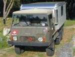
Thomas E.
Sonora, CA
712 Camper
[img][url]M:\avatar\DSCN0010%20(Custom).JPG[/url][/img]
Sonora, CA
712 Camper
[img][url]M:\avatar\DSCN0010%20(Custom).JPG[/url][/img]
-
texas pinzgauer
- Posts: 1062
- Joined: Mon Nov 19, 2007 2:43 pm
- Location: Houston, Texas USA
garage queen?
That's Adam Blank's K you're looking at Andy!
Looking for next new (for me) toy
1974 712M - sold
1973 710M - sold
https://www.facebook.com/profile.php?id ... 3094951494
1974 712M - sold
1973 710M - sold
https://www.facebook.com/profile.php?id ... 3094951494